Friday, 19 August 2011

Campbellton to Halifax

Distance travelled over last 11 days: 930 km
Total distance: 7525 km

Since Campbellton, I have cycled through many Acadian towns and villages. Acadians, by definition, are French-speaking Atlantic Canadians, so my French hasn't been completely useless since Quebec. The Acadian flag - blue, white and red stripes adorned with a single gold star - has been a prominent sight on businesses, outside homes, and painted on telephone poles.

I made stops overnight in Bathurst, Miramichi and St. Louis de Kent before reaching the Moncton area. Instead of stopping in Moncton, however, I kept pursuing a slight diversion to Hopewell Rocks. I didn't quite make it to the campground near Hopewell, so I relied on the generosity of a couple who let me tent on their lawn for the night.
Escuminac, NB, on the way to Moncton
I had checked the tidal information for Hopewell Rocks, so I knew low tide would be at 6:30 am, before the park opened. I got to park at opening time - 8 am - and made my way down to the beach area so that I could walk amongst the fascinating arches and flowerpots before the area closed at 10 for the incoming tides. After making brunch at the park, it was about high tide, so I made my way to an observation point to see the rocks one more time.

Arches and flowerpots!
The rocks at low tide
The same rocks at high tide
After my time at the park, I backtracked into Moncton. I found a Chinese buffet with a fabulous dessert bar, and connected with Pastor Troy and Sister Jan of Highfield Street Baptist Church. They gave me a place to pitch my tent for the night, and welcomed me into their church for Sunday morning. Troy is very knowledgeable about camping, cycling and all manner of outdoors activities, which made sharing my adventures more fun.

Two days later, I was at the 14 year old Confederation Bridge. Unfortunately, pedestrians and cyclists have to take a shuttle across the 13 km long bridge, even though I think there is plenty of room to cycle down the shoulder!

Confederation Bridge, NB side

Prince Edward Island is hillier than I bargained. By the time I reached my couchsurfing destination at Karyn's place, I was wiped. The next day, I covered the remaining 20 or so kilometers into Charlottetown and did sightseeing in the area before connecting with Karyn's sister, Suzane, and her husband, Mark, both eager fair-weather road cyclists.

Hay bales in PEI, and Northumberland Strait in the distance
Red rocks and a lighthouse near Victoria Park
I left Charlottetown, headed for Halifax, NB. Between the cities lay roughly 225 km of  road, and 25 km of water, which I traversed via ferry. I got some great views of PEI's coastline and red rocks from this vantage point.

What a funny looking sailor!

There are four exits to this roundabout, and they all look like this!


What would "New Scotland" be without sheep?!
I stayed on quiet secondary highways almost the entire way into Halifax. I split the cycling over two days, camping in the little town of Middle Musquodoboit. In Halifax, I have been treated to the hospitality of brother Larry and his wife, Lorna. Today, we took a drive with brother Albert and sister Priscilla down to Peggy's Cove, the quintessential lighthouse. Despite foggy and overcast weather, it was warm and breezy - perfect weather for a lighthouse!

The lighthouse at Peggy's Cove

Monday, 8 August 2011

Quebec to Campbellton

Distance traveled over last 6 days: 544 km
Total distance: 6595 km

I had spent a couple rest days, but finally, I was ready - except for one thing: in the morning, before departing from Quebec for the south shore of the St. Laurent, I stopped at Option Velo to true up my rear bicycle wheel. I also got a general inspection & maintenance done on my bike. Max, my host in Quebec, accompanied me and directed me to the ferry which crosses the river over to Lèvis.

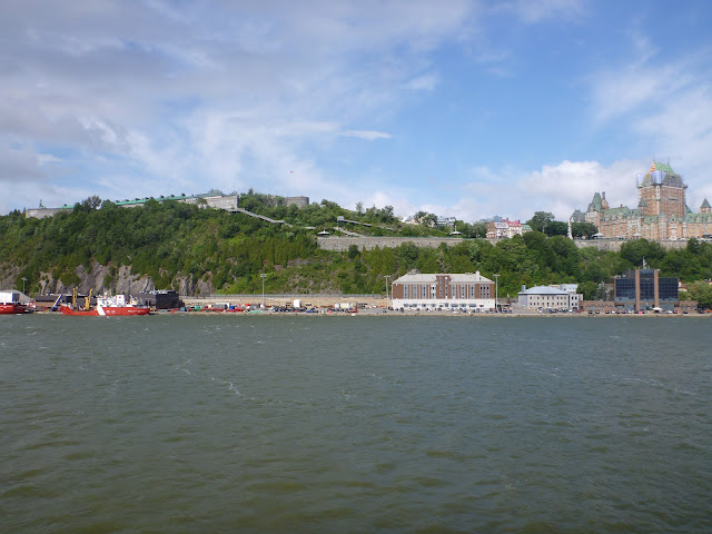
The ferry ride is spectacular. From the water, you get what is possibly the best view of Chateau Frontenac. From here, I finally started to grasp how large the castle is. Then, looking down the river to the citadel, I realized what a formidable fortification this must have been when General Wolfe was trying to capture Quebec. The sheer cliffs and ominous walls safely guard the fortress from a direct attack. Turning around and looking to the south shore, you can see the remnants of the British fort located in Lèvis.

The Chateau as seen from the St. Laurent
The Citadel behind the cliffs, and the Chateau
 Riding the south bank of the St. Laurent is just as pleasant as the north bank. Like the north, it is populated almost everywhere, with lots of small towns along the way. Despite strong headwinds of 30-45 km/h for a couple of days, the cycling was beautiful and enjoyable. The wind that came from the north-east was cold, which helped offset my body heat and solar radiation during the noontime, but in the evenings, it got chilly if I wasn't in my tent!

Pretty sights all along the way
I spent a couple of nights stealth-camping in small towns along the way: Cap-Saint-Ignace and Sainte-Andrè. The latter bordered on untamed territory popular with mountain hikers; I was only awoken by the howls of pack-wolves three times that night!

The wild is not far away!
Onwards I traveled to Rimouski, and as I made my way, I started to observe the widening of the St. Laurent. In Rimouski, I stayed at a mediocre hostel to recharge my electronics, shower, and get a comfy rest. In the morning, I had to stop at a bike shop as I had picked up a broken spoke 10 km earlier. As I made my way out of town, I cycled past a show & shine, and then along the seawall. Finally, the smell of the ocean was in the air. Unfortunately, I would be leaving it in preference of the shorter inland route through Gaspesie via highway 134.

Cycling along the Rimouski seawall
This quiet highway, which traversed through sections of hilly terrain, offered some lovely panoramic views full of depth and perspective. The route apexed near the end of the day at Matapédia Lake. Day one of the two-day jaunt through Gaspesie was sunny until my destination in Amqui. I took some time to view the pretty gardens and pond, but soon the weather changed. I ran out of time while choosing a place to stealth camp, and had to take shelter under the library for about a half hour while a thunderstorm ran its course through the area. A brief respite in the rain gave me enough time to set my tent at the back of library, in a dark and wooded area beside a stream. I cozied up for the night at the back of the library, thinking I would be alone...

Beside the pond in Amqui
A couple hours later, I was awoken to some rowdies in their truck. It was a Saturday night - not necessarily the best day to stealth camp. Obviously bored and intoxicated, they drove their truck onto the grass and buzzed by me a couple of times. Needless to say, that got me pretty worried. They were still loitering around nearby, and from what was teaching my ears in my tent, probably still drinking or smoking. I didn't know how far they might want to take things. Also, they were Francophones: I wasn't prepared to understand their banter or even communicate with them, so I decided to call the police.

Thankfully they left on their own accord soon afterwards, before the cops showed up. The police were very understanding, and reassured me that they would patrol the area periodically throughout the night. I was able to settle down and get a good rest after that.

The second day through Gaspesie was rainy the whole way. I had my sights set on the town of Matapédia, where I thought I might find a restaurant or coffee shop, but to my dismay there was nothing of the sort. Thankfully, the trip to the next town was short: less than 20 km into Campbellton, NS. Lucky for me, there was a McDonalds where I could dry off, and, for the first time in my trip, I succumbed to the lure of a Big Mac! It was roughly 4 pm, and I hadn't eaten all day: wanting to leave Amqui in the morning before the rain hit, and not wanting to stop on the road and get chilled by the rain and wind meant the only thing in my stomach to this point was a Cliff Bar.

It was still early in the day, leaving me with several hours to spend in Campbellton. The local hostel was full, so I stayed at the McDonalds until it was late enough to look for a stealth site. This time, I spent the night in peace. Due to an inclement weather forecast, I figured I should rest up for a day in the town before heading for Bathurst, Hopewell Rocks, and eventually, PEI.

Getting to work in the café
More hard work, but somebody's gotta do it
It's Restigouche Sam, Campbellton's biggest fish!
J.C. Van Horne Bridge at sunset, which spans the Restigouche River and connects QC to NB

Friday, 5 August 2011

Ottawa to Quebec

Distance traveled over last 8 days: 659 km
Total distance: 6051 km

Before leaving Ottawa, I took a second rest day to run errands and ultimately connect with the parents of university colleague Phil: Phil (Sr.) and Joan. It meant backtracking a bit to Kanata, but after a couple of days of being in the city, I had already learned the dedicated bike paths in Ottawa that connect the municipalities and get you off the road, so getting to Kanata was pretty easy. The time I spent with Phil and Joan was full of story-telling and good food. Sometimes it's hard to get to bed at a proper hour when the company is so good!

After a restful night, I set my course for the Francophone province of Quebec. Now, the last time I spoke a word of French was at least six years ago, in high school. Some of those lessons must have stuck, because I was able to construct vital sentences like "Puis-je utiliser la toilette, SVP?" and "Pouvez-vous donner moi de l'eau?". On the other hand, Quebecers don't speak like the exaggerated audio tapes we had in French class. When that mush of sound ("real French") hit my ears for the first time, I was dumbfounded by trying to figure out how many words were hidden in it! Even after a week or more in Quebec, I often have to resort an embarrassing smile and nod after requesting a couple of repetitions!

Quebec has a fantastic provincial cycling route known as "La Route Vert", which consists mainly of secondary highways with wide shoulders and great pavement. Cycling around here has been fun and scenic. Even flat tires don't break your attitude here. There are many opportunities to view the banks of the Saint Laurent river, and you can cross over to the other shore at various "traversieres" - or ferry crossings - along the way.

These roads take you through many little towns and lots of farm land. Every town has a big, fancy Catholic church - a remnant from the history of the settlers. Much of the farm land is dedicated to corn; the husks stand very tall in the fields now.

Fields beside the St. Laurent
La Route Vert is popular with many cyclists - not just the touring variety. For the first time in my trip, I've had cyclists on training rides slow down to my leisurly pace just to have a conversation about my trip - once in French, and another time in English.

I've met many friendly and outgoing people around Quebec, and I think that's the norm - as long as you're not jaded, senile, and ultra-Anglo like another cycle-tourist I met. I think he got the cold shoulder a lot just because he couldn't approach people in French.

I've had a couple major stops along this segment of the trip, the first being Montreal. Here, I met up with Brothers Dennis and Lewis, and enjoyed an official smoked meat sandwich from Schwartz's while enjoying the view atop Mount Royal. I also ascended up the Olympic Stadium elevator, and visited the amazing botanical gardens. The gardens have several themes, including Chinese, Japanese and Arctic gardens, and a collection of "economically useful" varieties on display, such as wheat, berries, and spices.

Olympic Stadium and the integrated observatory

Chinese garden display

Flowers!
The next major stop was the city of Quebec, but to get there, I first needed to split the distance in Trois-Rivieres with Richard and his family. We enjoyed a tasty kebab dinner together on the patio, and afterwards, made our way into the city center to see some of the historic landmarks and the busy night life. Thanks to Richard, I got a strong start the next day with a guided exit out of the city, a "bon voyage" sack of nourishment for the road, and some suggested stops along the way. It was along this route that I had my first French-Canadian poutine. But to my error, I got the large "galvaude", which turned out to be too much to handle with the added chicken and peas. I ate it all, but had to take about an hour and a half to digest before I could get back on the bicycle! Even then it was tough to keep going!

Along the banks of the St. Laurent
You mean I have to eat this and then keep on cycling?!
Finally, I was in the city of Quebec, or just "Quebec", as they say around here. I stayed with the really cool, really outgoing couple, Max and Emilie (www.mangerlaroute.blogspot.com). There are so many sights in this city, and a lot of history to accompany it. Max gave me a bicycle tour of the old city and the chateau. Later, I was able to walk around the walls of the citadel (where there exists an active military base), tour the parliament building, and walk through some of the streets of both the upper and lower parts of the old city.

Standing outside the Chateau
An artists' market in the old city
Quebec Parliament
A street in the old city
I had planned to leave Quebec after just one rest day, but as I departed, a rainstorm caught me, and I headed for shelter in the marketplace. To my dismay, my camera was destroyed by the rain. I was coerced into buying a new, weatherproof model to chronicle my travels before leaving the city. Since I knew I would no longer be leaving Quebec today, it also gave me an opportunity to cycle north and view the falls at Montmorency. Back when this territory was occupied by the French, General Wolfe tried unsuccessfully to attack Quebec from this point. The English sustained heavy losses in their assault. Later, Wolfe would launch a surprise attack on the Plains of Abraham, where they were finally took control of Quebec.

Montmorency Falls
After the turn of events with my camera, Max and Emilie were kind enough to let me stay another night in advance of catching the ferry to Levis. That is where the blog will pick up from next time!